The Runit Dome Dilemma: Rising Tides, Lingering Shadows
Located halfway between Hawaii and Australia in the vast expanse of the Pacific Ocean lies a haunting reminder of the U.S.’ nuclear testing legacy—Runit Dome.
The dome symbolizes the dual tragedies of a changing climate and a toxic past, both present realities that the Marshallese people, distant from much of the world’s eyes, are left to confront.
Amidst the beauty and isolation of their Pacific home, they face disasters not of their making—an aging, leaking concrete tomb filled with the radioactive remnants of Cold War-era experiments and the rising tides of climate change.
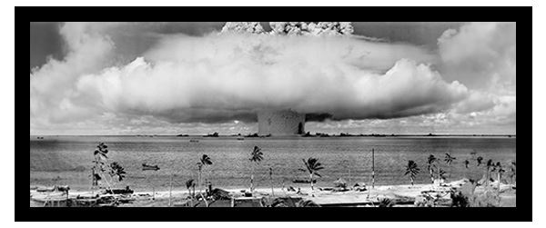 The BAKER test, conducted on July 25, 1946, was the first underwater test of a nuclear weapon.3 (The image has been modified from its original size using a generative AI tool.)
Atomic Trials: The Marshall Islands as a Nuclear Proving Ground
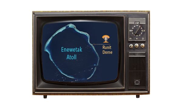
The Marshall Islands are a remote collection of 29 atolls and five isolated islands1 spread across an enormous oceanic territory of nearly 2,000,000 km2 (over 750,000 sq. miles) in the Pacific.2 During World War II, the U.S. gained control of the islands and built military bases on Kwajalein and Enewetak atolls.3
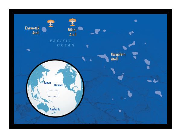 U.S. nuclear testing in the Marshall Islands occurred on the atolls of Bikini and Enewetak, both located in the northwest of the country.
After the war, the U.S. settled on the islands as the ideal location to test unfathomably powerful nuclear weapons due to:
- their remoteness,
- the small—and scattered—population of about 50,000 people in the mid-1940s, and
- the presence of the U.S. military bases. 3
The serene atolls of the Marshall Islands, once obscure dots in the Pacific Ocean, became ground zero for U.S. nuclear weapons testing beginning in 1946. Between 1946 and 1958, the United States conducted 67 tests in the Marshall Islands,3 transforming its tranquil lagoons and pristine beaches into one of the most contaminated places on Earth.
 Operation Crossroads was the first series of tests conducted by the U.S. in the Marshall Islands. Designed to test the effect of nuclear weapons on warships, three tests were conducted between July 1, 1946, and August 10, 1946.
Bikini Atoll is perhaps the most famous test site on the islands, as this is where U.S. nuclear testing in the Pacific began on July 1, 1946. On March 1, 1954, the atoll also served as the site for a test code-named Castle Bravo, the largest ever nuclear detonation by the U.S.—1,000 times more powerful than what was dropped on Hiroshima.3
Of the 67 nuclear tests in the Marshall Islands, 43 were conducted on Enewetak Atoll,4 located in the northwest corner of the Marshall Islands territory. It was home to the world’s first successful thermonuclear (i.e., hydrogen) bomb test on November 1, 1952.3 Flag of the Marshall Islands.
Not all tests were successful. For example, on August 6, 1958, a test misfired on Runit Island—one of the islands of the Enewetak Atoll—releasing plutonium fuel.5
The immediate impact of nuclear testing on the once-pristine landscape was dramatic. On Enewetak, four islands were completely vaporized, with one powerful bomb leaving a crater 2 km (1.2 mi) in diameter.6 But the deepest scars left behind were perhaps unseen—many Marshallese had lost their ancestral home, a loss with repercussions that would resonate through generations. Flag of Bikini Atoll. The phrase on the flag translates to “Everything is in the hands of God,” the words spoken by King Juda in 1946 regarding the relocation of islanders.
Radiation and Relocation: The Human Cost
In February 1946, the U.S. military governor in the Marshall Islands, Navy Commodore Ben Wyatt, was tasked with convincing the 167 native Marshallese on Bikini Atoll to temporarily leave their homeland for “the good of mankind and to end all wars.”7
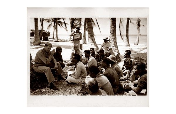 Com. Ben Wyatt’s public meeting with King Juda.
As was documented in the short film Bikini – The Atom Island, King Juda, the leader of the Bikinian people, agreed with the relocation. However, he likely had no choice in the matter. The U.S. government got to work relocating the native population to Rongerik Atoll, a previously uninhabited ring of islands with limited resources located ~200 km (125 mi) east of Bikini.3
Throughout the years of nuclear testing, other groups of Marshallese would be relocated from their homes. However, some of these relocation efforts came after locals were already exposed to fallout from nuclear testing.
While the Castle Bravo test produced the most powerful detonation ever by the U.S., it was deemed a radiological disaster that served as a catalyst for worldwide backlash against atmospheric nuclear testing. Originally expected to yield five to six megatons of TNT, the bomb was immensely more powerful, producing a 15-megaton yield—about 2.5 times more destructive than initially estimated.8
Effects of the blast quickly reached Rongelap, Rongerik, Alinginea, and Utirik atolls, and evacuation efforts by the U.S. were not fast enough to prevent an estimated 665 people from being overexposed to radiation from Castle Bravo.8 Some locals suffered acute radiation poisoning, with side effects including hair loss, burned skin, and vomiting.5
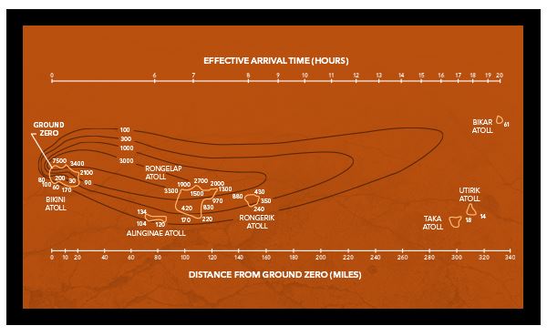
The nuclear fallout plume from the Castle Bravo test quickly traveled across the Marshall Islands. The graphic below shows the plume's path, with contour lines and data points in rad, a unit of absorbed radiation dose. For reference, the U.S. Department of Homeland Security states that 50% of people exposed to 400 rad will likely die within 60 days without medical intervention.
As many Marshallese learned, returning home was difficult—if not impossible—even decades after the nuclear tests stopped.
Bikini Atoll was eventually declared “radiologically safe” by the U.S. government, and around 100 families moved back in 1974. However, scans of residents revealed the environment was still too dangerous. Radioactive elements were being taken up by palm trees and passed on to coconuts, which were then ingested by the locals. Due to the unsafe conditions, residents were forced to flee their islands—again—in 1978.9
In the early 1970s, the U.S. determined Enewetak Atoll was a candidate for radiological cleanup. The U.S. was committed to rehabilitating the environment and returning the land to the Marshallese. However, because this circle of islands took the brunt of the testing, the process would be challenging—and very costly. It would end up being the largest nuclear cleanup in U.S. history.6
A Controversial Solution: The Birth of The Tomb
Beginning in January 1973, the U.S. government conducted various studies to help determine the best cleanup method—ocean dumping vs. crater entombment (i.e., placing debris in a crater and capping it)—at Enewetak Atoll. Although ocean dumping was the preferred choice,11 the U.S. Environmental Protection Agency (EPA) stated it would likely not be permitted—it would take years to seek a permit with no guarantees it would be approved.10
Preparatory cleanup activities began on March 14, 1977. In June, a group of contractors raised concerns about the plan for a concrete dome, as it would “not remove this material from environmental interaction, since direct ocean water connections into the crater exist.” While the concerns were valid—and another disposal plan may have been a better fit—it was too late to change course. The debris would be buried.10
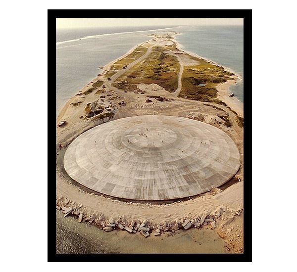 Aerial view of Runit Dome as construction neared completion. The structure is 114 meters (374 feet) in diameter, 7.4 meters (24.3 feet) tall, and holds over 76,500 cubic meters (~100,000 cubic yards) of radioactive debris—over 30 Olympic-sized swimming pools.4
The Enewetak Cleanup Project—the construction of a containment structure known as Runit Dome, called “the tomb” by locals6 —was officially completed between July 1977 and September 1979.10
During this time, over 4,000 U.S. military personnel descended upon Enewetak to remove over 76,500 cubic meters (over 100,000 cubic yards) of contaminated soil and debris, mix it with cement grout, and dump it into a crater left behind from a test on Runit Island.4
The crater was topped with a dome-shaped cap 0.45 meters (17.7 inches) thick and 114 meters (374 feet) in diameter designed only to protect against natural erosion,4 not to act as a radiation shield. As the cap was being constructed, highly contaminated metallic debris was found and embedded directly into the concrete cover.5
Unsurprisingly, the Marshallese—initially led to believe the dome was to serve as a radiation shield—continue to be skeptical of its design.5 Initial plans called for the bottom of the crater to be lined with concrete, but this was abandoned due to cost, leaving only the remains of nuclear tests on the crater floor.6
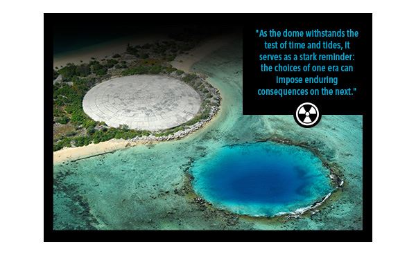
Below this debris is coral sediment that is notoriously porous,6 allowing seawater to seep into the structure. With groundwater levels that mirror sea level, the dome is now bobbing with the tides—radioactive water is being flushed into the lagoon daily.5 With rising sea levels, the situation will only get worse.
 Facing Rising Tides: The Climate Threat to Runit Dome
The Marshall Islands, like many low-lying atolls, are particularly vulnerable to the effects of climate change.
With a mean elevation of ~2 m (6.6 ft),1 the low-lying islands are now at the forefront of a global environmental crisis—rising sea levels pose an existential threat. Depending on the estimate, the rise in sea level in the islands could be over 60 cm (23.6 in.) by 2100, enough to submerge about 75% of the country.12
The Marshall Islands are already experiencing more frequent tidal flooding, intense storm events, and other climate change impacts, such as coral bleaching and droughts. It is expected the Marshallese food sources could soon be compromised due to the collapse of reef ecosystems, inundation of crops, and saltwater intrusion into aquifers,13 leaving the residents of this once-tropical paradise with little to survive on.
 In many ways, the climate crisis is a more significant threat to the Marshallese than a tomb of leaking nuclear waste. With nuclear testing, some residents had to be relocated to another atoll or island, but rising seas may force some to leave their country entirely.
The Marshallese have limited options to manage their changing climate. According to a recent report funded by the World Bank on Adapting to Rising Sea Levels in the Marshall Islands, there are several adaptation pathways:13
• Protect the land through structures such as concrete sea walls, but these are expensive, can limit access to the sea, and can only effectively withstand sea level rise of up to 0.5 m (1.6 ft).
• Raising buildings is only effective up to 0.25 m (0.82 ft) of sea level rise, while land raising is a much more effective solution. However, raising the land is unlikely, as it would require the demolition of current structures before redevelopment could occur.
• Land reclamation would require developing new land where there is currently sea. As one can imagine, this would be very expensive, complex, and significantly impact the environment. In an extreme sea level rise scenario, the only option the Marshallese may have if they want to remain in their homeland is to reclaim and raise their lands.
• The Marshallese may also choose to leave, although this would have devastating social and cultural impacts on the community.
Regardless of what the Marshallese choose to do about protecting their homeland from the effects of climate change, there is little they can realistically do to address the tomb of toxic nuclear waste left behind by the U.S., at least on their own.
A Fragile Future: The Uncertain Fate of Runit Dome
The U.S. did not consider the effects of climate change when constructing Runit Dome, and now the encroaching water—reaching higher up the sides of the structure each year—threatens to erode its base, potentially leading to the breach of its contents.
Compounding this issue are the stronger and more frequent storms driven by climate change. Such storms could hasten the erosion process or even damage the dome’s structure directly, leading to the release of radioactive material. The dome, originally designed with the technology and environmental assumptions of the 1970s, is ill-equipped to withstand these new climatic realities.
 In response to concerns raised by the Marshallese—and others in the international community—about the integrity of Runit Dome, the U.S. Department of Energy (DOE) prepared a report for Congress in 2020. In it, the DOE maintained the structure was doing what it was intended to do—reducing erosion of the contaminated contents—and there was no danger of immediate failure.4
While the DOE’s report did confirm the cap has developed cracks, it stated there were no data to suggest any negative environmental impacts in the next 20 years, and radiation exposure for those living at Enewetak is below international standards. However, it did recognize the need to collect more data to more accurately determine the impacts of the leaking dome. The DOE concluded its report by stating nothing needs to be done beyond preventative maintenance.4
Despite the DOE’s conclusions, a comprehensive plan to address the dome’s long-term stability and ensure the safety of the Marshallese people remains elusive. One thing is clear—the structure will eventually fail, whether by gradual erosion or during a strong storm.
Echoes of a Troubled Past, Calls for Future Action
In the shadow of Runit Dome, the Marshallese continue to navigate a legacy not of their own making. As the world grapples with the dual challenges of addressing historical environmental damage and the mounting climate change crisis, this remote concrete tomb of nuclear waste transcends its physical boundaries. It represents a broader call for responsibility, awareness, and action.
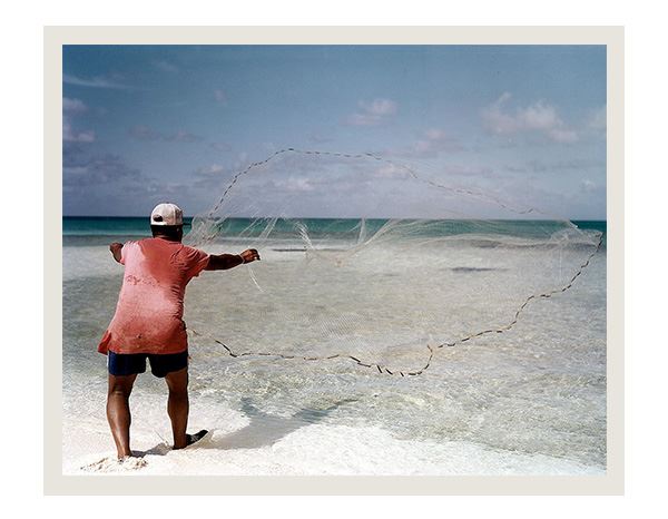 A survey team member taking marine samples from Bikini Atoll on November 15, 1978.
As the dome withstands the test of time and tides, it serves as a stark reminder: the choices of one era can impose enduring consequences on the next. The resilience of the Marshallese, facing visible and invisible threats, echoes a global need for environmental stewardship that honors our past and our shared future. The Runit Dome dilemma, a confluence of history and environmental urgency, is not just a Marshall Islands issue; it’s a global call to action, demanding attention, empathy, and a concerted effort to forge a path toward rectification and resilience.
Additional Information
High Price to Pay:
The Marshallese aren’t the only ones suffering from the impacts of nuclear testing in the islands.
The 4,000 U.S. soldiers who worked to build the dome on Runit Island were promised a unique work assignment in a tropical paradise. Instead, they were exposed to nuclear waste with little to no protection.12
When the soldiers first landed on the island, they were provided gear that would (presumably) keep them safe as they worked to clean up the atoll. However, once a military film crew finished taking pictures and videos, soldiers were forced to turn in the gear,15 leaving them with only shorts, t-shirts, hats, and jungle boots.12
Some soldiers claim they were eventually provided safety gear, but it was either delivered too late or was faulty.16
The U.S. soldiers were directly exposed to some of the most toxic substances on Earth, including pieces of plutonium from a failed test that occurred on the island. Not only did they have insufficient gear, some claim they received no radioactive decontamination training.12
The U.S. government maintains soldiers who participated in the cleanup encountered low levels of radiological contamination and now have a low risk of health problems.17 However, hundreds of these ‘atomic veterans’ have experienced a variety of health problems, including cancer and congenital disabilities in their children.15
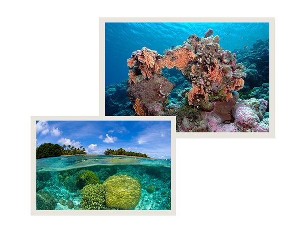
 Resilient Reefs: Corals Adaption in Bikini Atoll
Stanford researchers are investigating how corals at Bikini Atoll have thrived amidst radiation from nuclear tests conducted over 70 years ago. Unlike humans, these corals seem unharmed by radiation, potentially offering insights into DNA preservation and cancer resistance. This unexpected resilience amidst historic fallout offers a unique opportunity to understand genetic adaptations to extreme environments while reminding us of the enduring impact of nuclear activities on ecosystems.14
 Advancing Nuclear Water Quality Monitoring
While the Runit Dome dilemma underscores the challenges of nuclear waste legacy, it also highlights the importance of innovative solutions in monitoring and managing such environments.
Sellafield Ltd in the UK faced a daunting task—the safe decommissioning of a nuclear waste pond dating back to the 1950s with over 14,000 cubic meters of contaminated water.
Traditional water monitoring in such a highly radioactive environment posed significant challenges, including limited sampling locations, the risk of radiation exposure, and equipment failure due to intense radioactivity.
Sellafield’s solution was to deploy EXO water quality monitoring sondes (such as the EXO3) with pH, temperature, conductivity, turbidity, fDOM, blue-green algae, and chlorophyll sensors. The team found the sensors easy to calibrate and quick to swap with those deployed.
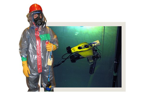 An EXO Sonde combined with an AUV.
Commenting further on the success of the EXO trials, Xavier Poteau, the project team lead, said: “It has been a common experience in the nuclear industry to have to apply significant adaptations to electrical equipment so that it can function correctly in a radioactive environment, and this can incur a heavy cost and time penalty. However, the EXO sondes have performed very well ‘off the shelf,’ which is a sign of good design.”
The introduction of the EXO transformed Sellafield’s approach to nuclear waste monitoring, allowing for comprehensive data collection in areas previously inaccessible and significantly reducing the reliance on manual sampling. This approach represents a significant step forward in environmental monitoring within the nuclear sector.

SOURCES
1 CIA, Explore All Countries—Marshal Islands
2 U.S. Embassy in the Republic of the Marshall Islands, Policy and History
3 Atomic Heritage Foundation, Marshall Islands
4 U.S. Department of Energy, Report on the Status of the Runit Dome in the Marshall Islands
5 LA Times, How the U.S. betrayed the Marshall Islands, kindling the next nuclear disaster
6 Australian Broadcasting Corporation, A poison in our island
7 National Museum of American History, Commodore Ben H. Wyatt addressing the Bikini Island natives
8 Brooking Institution, Castle Bravo: The Largest U.S. Nuclear Explosion
9 Woods Hole Oceanographic Institution, Back to Bikini
10 U.S. Department of Energy, Enewetak Radiological Support Project
11 The Guardian, This dome in the Pacific houses tons of radioactive waste—and it’s leaking
12 Australian Broadcasting Corporation, The Dome
13 The World Bank, Adapting to rising sea levels in Marshall Islands
14 Stanford, The radiation-exposed corals of Bikini Atoll may hold insights on cancer
15 New York Times, Troops Who Cleaned Up Radioactive Islands Can’t Get Medical Care
16 NBC News, ‘Atomic veterans’ overwhelmingly denied benefits for illnesses related to radiation exposure during service
17 U.S. Department of Veterans Affairs, Radiological cleanup At Enewetak Atoll