Why Remotely Care About Remote Sensing?
“Remote sensing” seems to be a buzzword at environmental conferences these days, and the sessions always attract enviable audience sizes. As a surface water quality field scientist, I didn’t initially think these discussions were meant for me. The remoteness of my data was related to how far outside of cell phone range I had to go to collect a sample or retrieve my sensors. I needed to find out how remote sensing fits into water quality.
A (Very) Brief History
I have come to learn that what is referred to as remote sensing is often specific to the use of satellites equipped with sensors to collect observations about the Earth, commonly referred to as Earth observation (EO). But it also includes aerial photography, dating back to the use of early cameras on balloons in the late 1800s, and has expanded since World War II to include radar, sonar, and infrared imaging.1,2
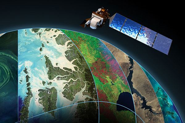
Figure 1. The Landsat Mission has been pioneering remote sensing for over 50 years. Credit: NASA
Remote sensing has been taking the world of environmental monitoring by storm since the launch of Landsat 1 in 1972, the first EO satellite that provided groundbreaking images of the Earth’s surface.1 Since then, the Landsat and other satellite mission data have been a valuable resource for environmental fields ranging from agriculture to forestry and beyond.3 Aside from this boon of imagery data, what else can remote sensing offer the field of water quality monitoring?
Water Quality from the Sky
Physical surface water quality data collection can be cost-, time-, and labor-intensive; field personnel must travel to a site to collect grab samples, use handheld in situ sensors, or perform deployment site maintenance. Even with a large network of sites, it can be difficult to have enough granularity in the data to pinpoint inputs and effectively monitor changes on a watershed- or ocean-wide scale. This makes the data less accessible, especially to communities with limited resources.
How do satellites help collect water quality data? Multi- and hyperspectral sensors aboard these satellites collect data across the electromagnetic spectrum. Visible to near-infrared wavelengths are the most relevant for water quality; the radiation reflected by water can be corrected for atmospheric effects to yield estimates for water quality parameters, such as turbidity, surface temperature, chlorophyll-a, colored dissolved organic matter (CDOM), and more.6
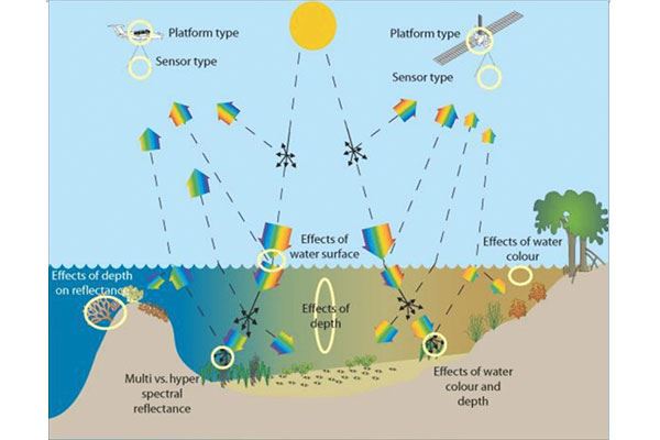
Figure 2. Schematic illustrating the path of sunlight interacting with the atmosphere, water column, and seafloor, and finally being measured by a satellite sensor. EOMAP
Compared to traditional on-the-ground (or rather in-the-water) methods, satellites can offer finer spatial resolution in near-real-time. Satellites are not limited to a specific area and can scan large regions in a short amount of time, providing a comprehensive overview of entire bodies of water at once, even in remote and inaccessible areas.
Satellites operate in Earth’s orbit, repeatedly passing over the same location. This means a satellite can conduct automated continuous monitoring of an area of interest. The result can be a high temporal resolution that enables the detection of long-term changes in water quality, such as seasonal variations, pollution events, and trends related to climate change.
A Part of Your Plan
Incorporating satellite technology can be a cost-effective investment in your monitoring plan. Satellites reduce the need for extensive fieldwork and the costs associated with traditional monitoring. They also make it more feasible to monitor water quality over large areas with limited resources.
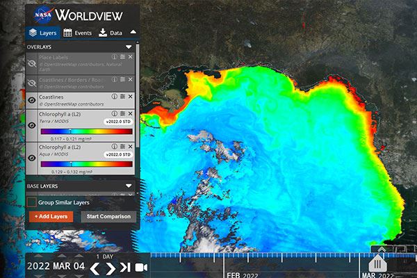
Figure 3. NASA's Worldview web-based tool allows for free public use of satellite data.
Some environmental satellite data are available through open, public resources, like the CyANWeb App, which aims to detect and quantify cyanobacterial algal blooms in lakes and reservoirs, and NASA’s Worldview App, which maps ocean data utilizing the NASA Earthdata database.4,5 These free resources are pivotal to exposing the public to the benefits of satellite data; but they do not offer the high spatial resolution needed for monitoring smaller inland freshwater bodies and coastlines. They are also limited to only a few water quality parameters and lack opportunities for customization.
Other satellite data services involve an associated cost to access the network, but they offer a more tailored experience to your monitoring objectives. These applications offer more analytical tools and water quality parameters, specialized mapping, and software features to improve your near real-time data experience, access to historical data, and the option to set up alerts for early warning of events. One example of this is eoapp AQUA, developed by EOMAP, Xylem’s partner (Fig. 4).
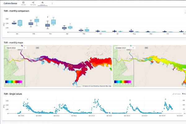
Figure 4. eoapp AQUA dashboard showing near real-time water quality data from satellites in graphs and map layers.
As the broader community has become more exposed to the capabilities of remote sensing through easily accessible software, field scientists are looking to satellites to solve the issues with scope and spatial variability that we encounter in the field of water quality monitoring.
>>> Sign up for a free eoapp AQUA demo <<<
Combining Two Good Things
While remote sensing is a leading-edge tool with the potential to improve the state of environmental monitoring, it is not a replacement for in situ sensors. In fact, monitoring programs would benefit most from pairing them together—the spatial and temporal resolution of satellite data complements data collected by spot sampling using handheld instruments and continuous monitoring using deployed sensors.
To conceptualize this, consider one of the most topical concerns in water quality: Harmful Algal Blooms (HABs). HABs pose a severe threat to aquatic life and human health. Satellite sensors can detect and monitor the proliferation of algae by measuring chlorophyll-a and phycocyanin pigment concentrations using specific absorption wavelengths and identifying bloom events associated with peak concentrations. Early detection of HABs allows for response teams to collect valuable field water quality data and collect grab samples to test for toxicity and algae identification. It also allows for timely interventions and mitigation measures, such as treatment application, water diversion, and risk communication to the public, reducing the impact on ecosystems and communities.
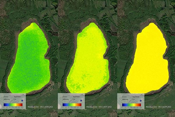
Figure 5. eoapp AQUA analysis shows increasing chlorophyll-a concentration in a lake over three days in summer 2022.
Another application of satellite data is monitoring turbidity and water clarity, which can affect aquatic habitats and drinking water sources. Satellites can measure the water’s optical properties, providing estimates of suspended sediment concentration. These data can help identify peak rainfall events or pollution sources, such as spillage of untreated sewage, prompting event-related sampling and source monitoring.
Remote sensing can help track trends in eutrophication, the process of nutrient enrichment leading to excessive plant growth and oxygen depletion. Parameters like Secchi Depth, chlorophyll-a, and total suspended sediment provide implications for the trophic state of a lake or reservoir. Some satellites have the ability to measure Trophic State Index (TSI) based on chlorophyll-a. Historical trends in TSI paired with water quality data and ecological observations can indicate the overall health of a water resource.
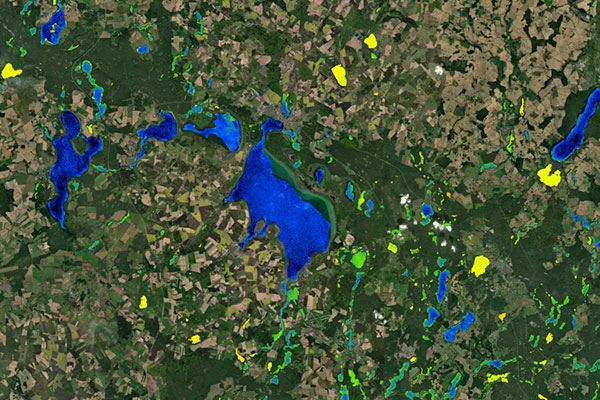
Figure 6. eoapp AQUA shows the variability of chlorophyll-a in small lakes in Northern Germany.
The last application I’ll mention is one of the coolest because it demonstrates how satellites can expand monitoring far beyond what is possible on the ground—using historical data and recent trends to observe sedimentation and erosion of riparian systems and coastlines on a macroscale.
These systems are naturally dynamic, but rapid changes such as increased deposition due to extreme flooding and fires upstream to rising oceans and receding coasts can be indicative of the effects of global climate change. Combining large-scale insights on these complex changes with water quality data in particularly vulnerable or sensitive regions, like floodplains and estuaries, can promote objectives to maintain biodiversity, protect marine and riparian resources, and sustain local economies.
Satellite data can inform you of the most effective locations to collect in situ water quality data and set up long-term deployment stations based on water movement and eddies, patterns in water quality, potential sources, and recurring events.
Today’s Advancements for a Smarter Tomorrow
Now we know there’s nothing particularly new about using satellites for EO, and we’ve seen several ways it can be applied to water quality monitoring— even through free, public resources. So, what exciting new developments are occurring in the field of remote sensing today that will drive smarter solutions in the future?
- Enhanced sensor capabilities: Ongoing improvements in sensor technology lead to higher resolution, greater spectral range, improved accuracy, and access to more parameters. These advancements will enable more detailed and precise monitoring of water quality parameters. eoapp AQUA satellites are sensor agnostic—they can work with any sensor and can adapt to accommodate future technologies.
- Physics-based algorithms: The application of algorithms based on the physics of light and water makes satellite data more accurate by improving corrections according to accepted calculations to convert light into water quality parameters. eoapp AQUA can apply these algorithms on any sensor from any satellite constellation anywhere in the world to account for atmospheric and water column properties, optical models, radiative transfer, sun glint, and more, providing unmatched data confidence. The algorithms also standardize data derived from different satellites, improving the comparability between data sources.
- Early-warning alerts: Programs that can assess satellite data against user-defined thresholds and send alerts directly to project managers and stakeholders allow for proactive decision-making. When water quality parameters exceed the thresholds, early-warning alerts make the near real-time data actionable, increasing the data utility. Response teams can operate more effectively and efficiently with changing conditions. With eoapp AQUA, this ability is paired with data-driven dashboards, historical reference datasets, and automatically generated reports to yield an intuitive and invaluable addition to any monitoring program.
Remote sensing is transforming the field of water quality monitoring, offering a powerful tool for environmental protection and sustainable management. Its ability to provide wide coverage, high temporal resolution, and detailed data on water quality parameters make it a strong asset for water monitoring programs. As satellite sensor technology advances, its potential to contribute to the health and sustainability of our water resources will only grow. Embracing this technology is essential for addressing the complex and evolving challenges of water quality amidst the climate crisis and securing safe water for all.

References
- Humboldt State University, History of Remote Sensing
- U.S. Geological Survey, What is a picture worth? A history of remote sensing
- U.S. Geological Survey, Landsat 9
- Environmental Protection Agency, Cyanobacteria Assessment Network (CyAN)
- The National Aeronautics and Space Administration, Water Quality Data Pathfinder
- Callejas, I, Nature Reviews Earth & Environment 3(9):556–556, Monitoring coastal water quality with satellite data
- Science Learning Hub Pokapū Akoranga Pūtaiao, Remote sensing and water quality
- Mohensi, F, et. al. Marine Environmental Research Vol 180: 105701, Ocean water quality monitoring using remote sensing techniques: A review